Met office hour-by-hour snow forecast as wintery showers set to hit Wales
Wales is braced for a sharp turn in the weather, with forecasters warning of a blustery, increasingly cold few days that could bring wintry showers into the mix by tonight and into the early hours.
Wales is braced for a sharp turn in the weather, with forecasters warning of a blustery, increasingly cold few days that could bring wintry showers into the mix by tonight and into the early hours. After a relatively mild start on Tuesday, conditions are expected to deteriorate steadily, with heavy rain sweeping eastwards and temperatures dropping. This comes following a week of sunny, spring-like weather across the UK.
The rain will start on Tuesday afternoon, then on Wednesday snow is due to land in Wales, with temperatures predicted to fall below zero on Wednesday night (March 25). This comes just a week after temperatures reached 20.9°C in west Wales , marking the warmest day in the UK so far. There are snow showers forecast across Wales from early on Wednesday morning.
Weather experts then anticipate a widespread frost on Wednesday night leading into Thursday morning. Here is when and where will experience heavy rainfall from Tuesday afternoon: 4pm: By 4pm, a band of rain will have moved more towards the east, with showers starting in Pembrokeshire while becoming more widespread in mid Wales. 5pm: Rain will be covering most of Wales by 5pm, with the worst of the showers in Powys.
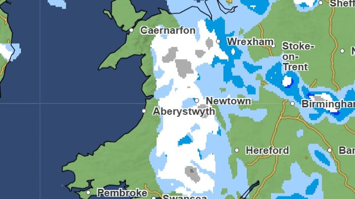
6pm: By 6pm, rain will be at its peak, with heavy showers affecting most of the nation. After 6pm, rain will gradually become more isolated until temperatures drop overnight and it turns to snow early on Wednesday morning. The first sign of snow is forecasted to appear in the early hours of Wednesday morning, affecting parts of north and mid Wales.
These wintry showers are predicted to persist throughout the day. At lower elevations, these showers will fall as rain. 7am: Much of Wales will be covered in snow at 7am on Wednesday.
8am: Snowfall will gradually ease off by 8am, moving eastwards. 12pm: Snow showers will have eased by midday with isolated outbreaks on high land surrounding Newtown. Steven Keates, Deputy Chief Forecaster at the Met Office, stated: "
After a spell of mild and brighter weather, the UK will turn increasingly unsettled in the coming days." "A series of weather fronts will bring periods of rain, strong winds and much colder air by midweek. Wednesday could be quite a shock to the system. "
Temperatures will range from 6°C. to 10°C, but it will feel closer to low single figures for many areas in the wind. Wintry showers are likely, especially over higher ground in the north, and a widespread frost – with icy patches for some – is possible on Wednesday night." Get daily breaking news updates on your phone by joining our WhatsApp community here .
We occasionally treat members to special offers, promotions and ads from us and our partners. See our Privacy Notice
Source Verification
Corroboration Score: 1This story was independently reported by 1 sources. Click any source to read the original article.